


ナビタイム ツーリングサポーター 原付バイク〜大型バイクまで

Description of ナビタイム ツーリングサポーター 原付バイク〜大型バイクまで
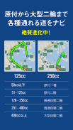
In addition to searching for the shortest route, you can also navigate by selecting a road that is fun to run, such as the scenic "
Touring Road
".
"big" and "simple"
considering driving on a motorbike (motorcycle/motorcycle) even during navigating.
Optimal navigation for riding a motorcycle
, such as voice guidance and modes that can be selected according to riding, support safe and comfortable riding.
Furthermore, touring is not the end of running. There is also a "biography" where you can leave memories of touring with the bike and customs.
From planning to memory management, there are plenty of functions for
enjoying touring
.
If you are looking for a motorcycle navigation app, this app is for you!
▼Main features (free)
Route creation
・ Route search via "route" and "touring road" (up to 8 locations)
・You can create a free route by tapping the place you want to go through on the map.
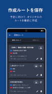
Save route
・You can save/reference created routes (up to 3 routes)
Maps
・A normal "white map" and a "black map" that is easy to see outside or at night can be switched automatically according to the time.
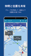
・Pin drop function and route search from current location
・Spot icons of "Motorbike Parking Lot / Gas Station / Convenience Store / Roadside Station" will be displayed.
・The touring road is displayed.
Point Search
・ Search by free word from 7 million spots nationwide
・Search around "motorcycle parking lot / gas station / convenience store / roadside station"
route search
・ Route search via "departure point" and "destination"
・Propose only one route out of "Recommended", "Expressway Priority", "General Road Priority", "Landscape Priority", and "Recommended 2"
・Check the ETC discount rate display/route information in text
Two-wheel traffic regulations
・Search for a route that considers the displacement of a motorcycle (motorcycle/motorcycle)
・Completely compatible with all types of mopeds, two types of mopeds, small two-wheeled vehicles, medium-sized two-wheeled vehicles, and large two-wheeled vehicles.
Touring Road
・Recommended scenic routes with more than 350 routes nationwide
・Suggest a "road" for touring based on the panoramic view of the route, the environment along the route, photos of the scenery that can be seen on the route, comments, etc.
・Check the location and detailed information on the map
・Route search/guidance incorporating all optional touring roads
Biography
・It is possible to look back on the memories with the motorcycle in a timeline format.
・You can save/reference the logs of touring (up to 3)
・"Customize" where you can post memories of customizing your bike with photos
・"Maintenance" to post the maintenance of the bike as a memory
・Retained for 60 days from the date of last use of "Biography Data"
(For personal information protection)
(The period will be extended by using this application again)
BikeJIN Course Information
・Limited collaboration with bike magazine "BikeJIN"! You can navigate the course published in the monthly magazine as it is.
In addition, you can now use voice navigation for free for a limited time, so please take this opportunity to try it!
▼Premium course features
Maps
・Congestion information is displayed as a line on the map
Point Search
・Prices are displayed on the nearby "gas station" search list
・Search from your home, my location (register any location), location history
route search
・Route search via "route" and "touring road"
・Propose 5 routes out of "Recommended", "Highway Priority", "General Road Priority", "Landscape Priority", "Recommended 2", and "Super Avoidance"
・Route search considering road congestion information and regulation information (based on VICS data)
・Compliant with two-wheel driving regulations so that only roads that can be ridden by motorcycle can be guided
Save route
・You can save/reference created routes (up to 20 routes)
Navigation
▽ Turn mode
This is a navigation mode that displays the information of the next guidance point in a "large" and "simple" manner.
▽ Map mode
This is a navigation mode that allows you to check guidance points and a map at the same time.
▽Compass mode
Direction guidance that displays the straight distance between destinations and the direction in a compass shape
This navigation mode is useful when you want to go to your destination without being disturbed by the navigation system.
▽ Other
・Lane guides, traffic signs, and 3D display of traveling lanes at intersections and junctions
・Voice utterance of intersection name
・Voice map / alert in the area where Orbis is installed
Biography
・You can save / refer to the log of touring (no upper limit)
・"Biography data" is always retained while registering for the premium course.
▼Premium Plus Course Features
Offline
・You can use the map even when you are out of service area.
・You can use the route search even if you are out of service area.
・Voice guidance can be used even outside the service area.
・Spot search can be used even outside the service area
*Since offline data is large, we recommend downloading over a Wi-Fi connection.
* 2.5GB or more of free space is required on the terminal to use offline data.
▽Caution▽
*For WIFI-only models, operation is not guaranteed in this service because operation may not be stable depending on the customer's communication environment.
*For models that do not have a GPS device, some functions such as current location map display and navigation cannot be used because they cannot capture their own location.
* This application is not intended for watching/operating the navigation screen while driving.
*Please park your car in a safe place before using it to watch or operate the screen.
*If the traffic regulation information such as road signs provided by the navigation system is different from the actual road conditions, please drive according to the local traffic regulations and signs.
* VICS regulatory information is data for ordinary vehicles.
▼About paid courses
"Premium Course" and "Premium Plus Course" are paid options.
Prices are as follows
[Premium course]
・Google Play payment monthly course [600 yen/month (tax included)]
・ Google Play payment annual course [5,700 yen / year (tax included)]
[Premium Plus Course]
・Google Play payment monthly course [1,000 yen/month (tax included)]
・ Google Play payment annual course [9,800 yen / year (tax included)]
We are currently running a campaign where you can try the monthly course for "31 days free" only for the first time!
*You cannot purchase with a "Google Play Gift Card".
▼Privacy policy of this app
Please refer to Menu > Help/Support > Privacy Policy on the upper left of the screen.
▼ Click here for bicycle touring!
■ Various route searches such as "cycling road priority"
■Search for nearby cycle stations
■ Display of the altitude difference graph of the route
Full of useful functions for cycling!
Please use it when riding various bicycles such as road bikes, cross bikes, mountain bikes, cyclocross bikes, fixie bikes and more!
Click here for an app that can perform navigation specialized for bicycles!
・
Bicycle NAVITIME
▼ Other recommended NAVITIME apps
NAVITIME offers apps for various travel scenes. Please see below for a list of services.
https://products.navitime.co.jp/
ナビタイム ツーリングサポーター 原付バイク〜大型バイクまで - Version 3.51.1
(02-04-2025)
ナビタイム ツーリングサポーター 原付バイク〜大型バイクまで - APK Information
APK Version: 3.51.1Package: com.navitime.local.bikeLatest Version of ナビタイム ツーリングサポーター 原付バイク〜大型バイクまで
Other versions


 3.64
3.64


Apps in the same category


